Geospatial Insights through Analysis
Unlock insights to transform decisions with precision using visualized and mapped solutions based on sound data analysis.


The MGeoS Process
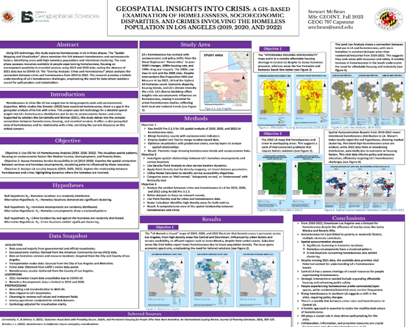
MGeoS proficiently analyzes geospatial data, leveraging tools like ArcGIS Pro, QGIS, SQL and RStudio for complex spatial and statistical evaluations. Analysis can include various geospatial imagery types, such as LiDAR, multispectral, hyperspectral and Spectral Aperture Radar (SAR) to extract actionable insights. Employing statistical methods, data fusion and machine learning techniques for both geospatial and non-geospatial data, MGeoS can create a comprehensive assessment of your problems and the potential solutions.
Click here for a more comprehensive list of many MGeoS services.
Analysis
GIS and remote sensing analysis combines spatial and satellite data to uncover trends, relationships, patterns, and changes. Remote sensing captures large-scale details like land cover and climate, while GIS integrates and analyzes this data for applications such as monitoring deforestation, urban growth, and disaster prediction.
From analysis ...
... to visualizing ...
... to understanding.
Remote sensing analysis, including advanced image processing, LiDAR operations and aerial photogrammetry informs the analysis process. MGeoS is able to manage databases, create custom GIS applications and utilize advanced geospatial intelligence techniques to support decision-making in emergency management, environmental monitory and strategic planning scenarios.
McBean Geospatial Solutions
Mapping the Future, One Solution at a Time
Feel free to use the form below or email: mcbean.geospatial.solutions at gmail dot com
© 2025. All rights reserved.